
The town of Itajai, located on the northern coast of SC, was highlighted during a panel on technology and sustainable development at the 28th United Nations Climate Change Conference (COP28) in Dubai, United Arab Emirates. The event featured technological activities designed to facilitate public access, such as applications, portals, systems and digital services.
 The city stands out for its initiatives that combine technology and management. Photo: Itajaí City Hall/Divulgação/ND
Technological actions created by Itajai to benefit the community were highlighted during a discussion at the UN conference. The software factory implemented by the Municipal Technology Department was presented by Codex, which took part in panel discussions at the international event.
The company is the representative of ESRI solutions in Brazil and develops Arcgis tools, a system used in the GeoItajaí project and in the disaster management portal developed by the municipality.
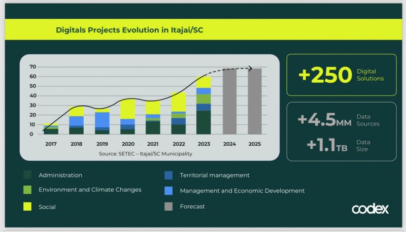
“This reflects Itajaí’s commitment to data management and technological innovation. Over the past seven years, we have developed more than 250 technology solutions for the population. The productivity of our municipal team is expressed in an average of three new digital solutions per month, which is a testament to our flexible ability to innovate and respond to social and environmental demands,” emphasizes Municipal Secretary for Technology Murilo Sodre.
Itajaí is ranked 17th nationally for governance, according to Connected Smart Cities. The position is ahead of Sao Paulo, which ranks 70th.
Itajai presents technology used during floods
Another success story presented at COP28 was the Itajaí Disaster Management portal. Developed using Arcgis geolocation software, the tool provides detailed information about floods and landslides that have occurred in the city.
 The growth of digital solutions in the city was noted at the UN conference – Photo: City Hall of Itajai/Reproduction/ND
In addition, there is information collected by the population and the Itajaí Civil Defense Service and published in the Conecta.Í application, which allowed decisions to be made quickly and efficiently, directing immediate interventions depending on the affected areas and the level of urgency. .
The site also contains information about incidents exchanged between various authorities, such as the Civil Defense, the 7th Military Fire Brigade and the Municipal Guard.
These include rescuing people and animals, landslides, landslides, moving to shelters, falling poles, etc. The portal also has information about shelters for people and animals opened in the municipality during the rainy season.
Another service available is river monitoring with graphs showing the levels of the Itajaí Açu and Itajaí Mirim rivers in the municipalities of Blumenau, Brusque, Rio do Sul and Itajaí.
By mapping and accurately locating flood-damaged streets in the city, this tool allowed the Municipal Works Department to organize post-flood cleanup efforts. The purpose of the action was to remove garbage and dirt, as well as contribute to the restoration of the city.
Source: Ndmais